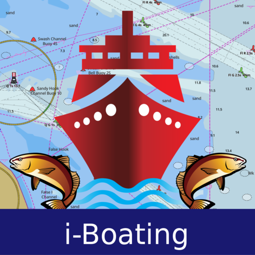
i-Boating:Marine Navigation
12276
·
1205053
#1 Marine Charts App offers offline nautical charts, inland river navigation charts, and lake contour maps w/ fishing AI, relief shading& lake depths. Only marine navigation app to have boat route assistance with Voice Prompts.Like having a Marine Chart plotter in one app!
Nautical Charts w/course up orientation. Incl Tide Charts & Currents prediction for nautical navigation. Create Boat routes / Waypoints, or import existing GPX/KML routes on device. Has Marine AIS(NMEA) support.
►FEATURES
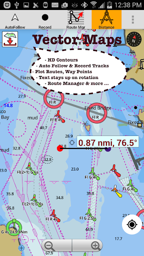
√ GPU accelerated offline vector NOAA charts/ENC charts (text stays upright)
√ Lake depth map shading/safety lake depth contours:custom boat safety depth
√ Maritime Aids to Boat Navigation : Beacons,Buoys,Boat Launch areas,Boat Ramps,Marina, Fishing Attractors
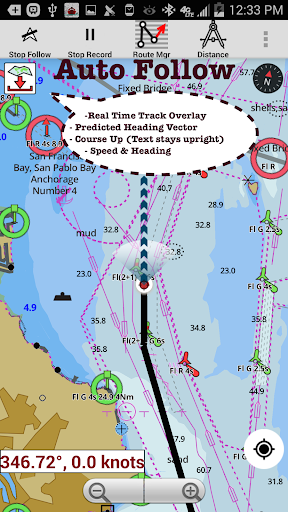
√ Record marine tracks, Autofollow with real-time track overlay
√ Voice Prompts for marine navigation
√ HD 1ft/3ft depth lake contour maps for anglers for selected lake maps: for fishing/trolling(freshwater/saltwater).
√ GPX/KML for boat route.
√ Seamless marine chart quilting: Coastal, Approaches,Harbour & Inland ENC(Electronic Marine Charts)
√ Superset of Navionics, C-Map,Lowrance,Argo,Wavve,Savvy Navvy,Predict Wind & Windy.
√ Waypoints
√ Tide & Currents.
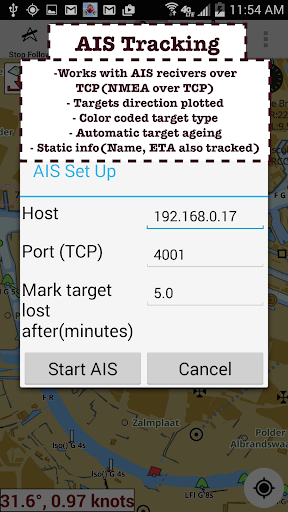
√ Marine AIS
√ Anchor Alarm
√ Magnify Text & Icons
√ Wind Prediction Overlay
√ Bearing True/Magnetic
► Fishing Hot Spots AI
►Lake Temperature Maps(Thermoclines 1°F (0.5° C)
►Relief Shading
► MAPS
Marine chartplotters details!
Unlimited updates for 1 year.
USA:Maps incl NOAA marine charts,ENC,USACE inland river maps & freshwater lake bathymetry maps for 75K+ lakes. Charts incl HD/1ft bathymetry. Incl NOAA marine charts(rasters) w/ NOAA ENC coverage.
Canada:CHS data Incl Great lakes,Alberta & Ontario lakes,Lake Simcoe&Trent Severn Canal,Quebec reservoirs.
UK/Ireland:UKHO marine charts
Germany:BSH charts,Waterways & rivers.
France
Europe Inland Rivers:Donau/Danube/Dunaja,Rhine,Rhein
Australia
Netherland/Holland
Croatia
Finland
Norway
Sweden
Brazil
Spain
Malta,Cypress,Mediterranean Sea
Caribbean
New Zealand
Denmark,Greenland,Faroe
Seychelles,Mauritius,Tanzania
Falklands
Malaysia,South China Sea
Persian/Arabian Gulf,Red Sea
South Africa
Argentina
Iceland
Fiji
Estonia,Latvia,Poland,Lithuania
Turkey,Greece,Italy
►Instrumentation
√Marine AIS & (NMEA AIS and GPS - TCP/UDP)
√Wind direction & Speed,Marine Sonar depth,Water temperature
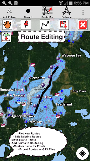
►ROUTE MANAGEMENT/TRIP PLANNING
√Create/Edit/Reverse Boat Routes
√Waypoints mgt
√Import GPX,KML & KMZ files
√Share/Export Routes,Boating log,Tracks&Markers
►BOAT NAVIGATION
√Auto Follow
*Real Time Overlay & Predicted Path Vector
*Course Up
*Speed & Heading
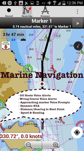
√ Route Assistance With Voice Prompts
*approaching boating route marker prompt
*RT nautical distance & ETA
*sailing/boating off route/wrong direction
√ Record Tracks
►TIDE & CURRENTS
*High/Low Tides
*Tidal Current Prediction
►Marine Weather
*GFS+ ECMWF
►SHARING
*Export GPX.
►Satellite Imagery
►USA Marine Charts
*Texas Lakes Texoma,Eufaula,Toledo Bend
*California Lakes Tahoe,Shasta
Pennsylvania Lakes Raystown
Florida Lakes Okeechobee,Kissimmee
*Minnesota Lakes Minnetonka,Waconia,Leech,Mille Lacs
*Massachussets lakes Quabbin
*Missouri Lakes Truman
*Ohio Lake maps Lake hoover
*Wisconsin Lakes Winnebago,Pepin
* Utah Lake Powell,Bear
*Maine Lake Sebago
*Alaska Lakes:Winnipesaukee
*Tennessee Lake Barkley,Norris,Watts Bar
*South Carolina Lake Keowee,Hartwell,Murray
*Lake Michigan,Huron,Ontario,Superior,Erie
►Canada Lakes Maps
*Lac Saint Jean
*Ontario Lake depth maps
*Rideau Canal-Ottawa River
*British Columbia Marine Charts
*Pacific Coast-Vancouver-Haida Gwaii
*Nova Scotia -Bay of Fundy
*Quebec-Anticosti Island
*Newfoundland
*St Lawrence river
*Manitoba & Saskatchewan
*Georgian Bay
*Puget Sound
►UK Nautical Charts
*Scotland
*Thames Estuary
*Ireland
►Australia Marine & Lake Maps
*NSW
*Queensland
Expand
Travel & Local
Download
Preview